
El Niño is one of the most powerful climate patterns on Earth. It begins in the tropical Pacific Ocean, but its influence can reach every continent by changing rainfall, heat, wind, drought risk, wildfire risk, tropical cyclone behavior, and seasonal storm tracks.
In 2026, El Niño is again at the center of climate discussions. The reason is not only that El Niño conditions are developing, but that several official forecasts indicate the event could strengthen significantly during the Northern Hemisphere winter of 2026–2027. Some media and climate communicators may call this possibility a “Super El Niño” or “Super-Forte El Niño.” Scientifically, the more precise term is “very strong El Niño.”
The most important point is this: El Niño is not a storm. It is a large-scale ocean-atmosphere pattern. However, by moving heat and moisture across the Pacific Ocean, El Niño can influence the conditions that help storms, heavy rainfall, droughts, heatwaves, and other extreme weather events develop.
El Niño is the warm phase of the El Niño–Southern Oscillation, commonly called ENSO. ENSO is a natural cycle involving the tropical Pacific Ocean and the atmosphere above it. The opposite cool phase is called La Niña, while neutral conditions occur when the tropical Pacific is close to average.
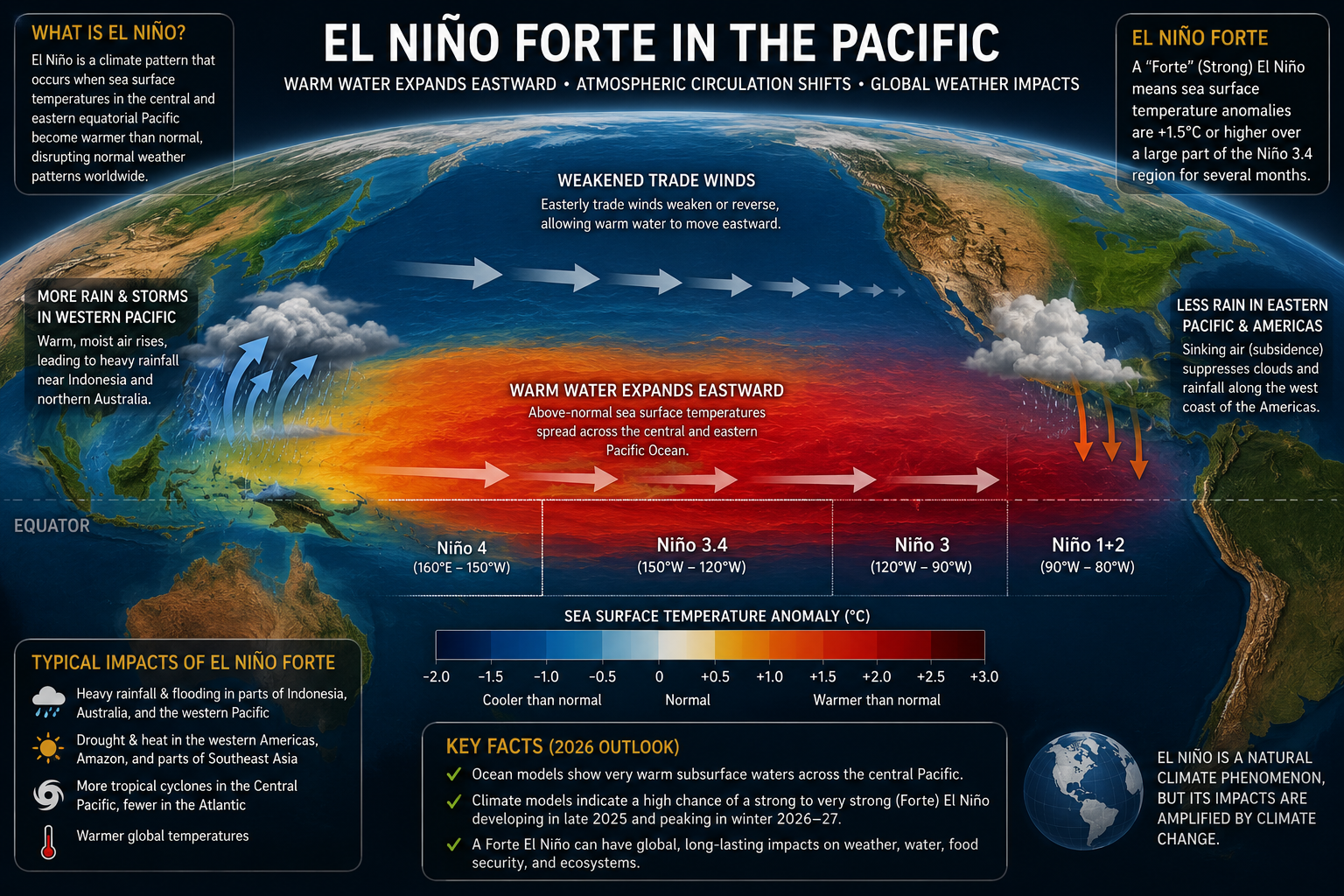
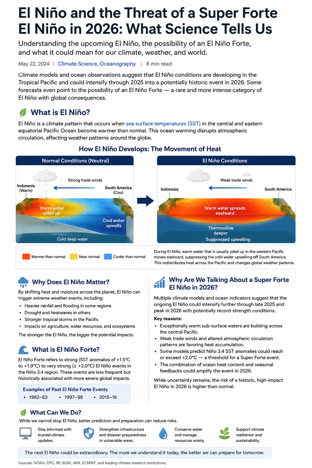
During normal conditions, trade winds blow from east to west along the equator. These winds push warm surface water toward Indonesia and the western Pacific. Near the west coast of South America, colder deep water rises to the surface in a process called upwelling. This cold upwelling is important because it supports marine life and helps keep the eastern tropical Pacific relatively cool.
During El Niño, the trade winds weaken. Sometimes they can even reverse for short periods. When that happens, warm water that is normally piled up in the western Pacific spreads eastward toward the central and eastern Pacific. At the same time, cold-water upwelling near South America becomes weaker. The result is a wide area of warmer-than-average sea surface temperatures across the equatorial Pacific.
That ocean warming changes the atmosphere. Warm ocean water releases heat and moisture into the air. Thunderstorms and tropical rainfall shift eastward. The Walker Circulation, a major tropical atmospheric circulation pattern, weakens or reorganizes. These changes can disturb jet streams and seasonal weather patterns far away from the Pacific.
A simple way to understand El Niño is to imagine the tropical Pacific as a giant tilted bathtub.
In neutral conditions, strong trade winds push warm water toward the western Pacific. Warm water piles up near Indonesia and Australia. The eastern Pacific, near Peru and Ecuador, stays cooler because deep cold water rises to replace the warm surface water that has been pushed westward.
During El Niño, the winds relax. The “pile” of warm water in the western Pacific is no longer held in place as strongly. Warm water spreads eastward across the equator. The thermocline, which is the boundary between warm surface water and cold deep water, becomes deeper in the eastern Pacific. Because the cold water is deeper, less of it reaches the surface. The ocean surface warms, and the atmosphere above it reacts.
This eastward movement of heat is why El Niño can change weather so dramatically. The Pacific Ocean covers a huge part of Earth’s surface. When heat shifts across it, rainfall zones, pressure systems, wind patterns, and storm tracks can shift too.
Many people say “the El Niño storm,” but that is not scientifically correct. El Niño is not a hurricane, cyclone, typhoon, or single rainstorm. It is a climate pattern that changes the background conditions in which storms form.
That distinction matters. A storm may last hours or days. El Niño can last months. A storm affects a region. El Niño changes the probability of certain weather patterns across large parts of the world.
For example, El Niño can increase the chance of heavy rainfall in some regions and drought in others. It can change tropical cyclone activity by altering wind shear, ocean heat, and atmospheric circulation. It can also contribute to higher global average temperatures because a large area of the tropical Pacific releases extra heat into the atmosphere.
This does not mean every region will experience the same impact. Even a strong El Niño does not guarantee flooding, drought, or storm damage in a specific location. It changes the odds.
“El Niño Forte” means “strong El Niño.” In climate monitoring, scientists often classify El Niño events by how warm the central-eastern tropical Pacific becomes compared with normal conditions.
A simplified scale is:
The “very strong” category is what many people mean when they say “Super El Niño” or “Super-Forte El Niño.” However, “super” is not the standard official category. The official scientific language is usually “very strong El Niño.”
Scientists are discussing a possible Super-Forte El Niño in 2026 because several ocean and atmosphere indicators are lining up in favor of a strengthening event.
First, El Niño conditions are already present in the tropical Pacific as of June 2026. Above-average sea surface temperatures have appeared across the central and eastern equatorial Pacific.
Second, warm subsurface water has been observed below the surface of the equatorial Pacific. Subsurface heat is important because it can feed surface warming later. In other words, the ocean does not only look warm at the surface; it also contains stored heat below the surface that can support further intensification.
Third, wind patterns are becoming more El Niño-like. Westerly wind anomalies in the equatorial Pacific can help push warm water eastward, reinforcing the ocean warming and reducing upwelling.
Fourth, official probability forecasts show a significant chance of a very strong event. NOAA’s June 2026 strength outlook gives a 63% chance that the November–December–January season will reach the “very strong” El Niño category. That is why late 2026 and early 2027 are the key periods to watch.
This does not mean a record-breaking event is guaranteed. It means the probability of a very strong El Niño is unusually high and deserves serious attention from meteorologists, emergency planners, farmers, water managers, energy planners, public health officials, and coastal communities.
A strong or very strong El Niño can increase the likelihood of unusual weather patterns around the world. The exact impacts vary by region and season, but common El Niño-linked effects include:
Heavier rainfall and flood risk in parts of the eastern Pacific, western South America, and the southern United States
Drier conditions in parts of Indonesia, Australia, southern Africa, and some tropical regions
Higher global average temperatures, especially when El Niño is combined with long-term global warming
Shifts in tropical cyclone activity, including changes in where storms form and how favorable the atmosphere becomes
Marine heat stress, coral bleaching risk, and disruption of fisheries in sensitive ocean regions
Agricultural stress due to drought, heat, delayed rains, or excessive rainfall depending on the region
The word “risk” is important. El Niño is not a weather script. It is a probability driver. It makes some outcomes more likely, but local weather still depends on regional climate patterns, land conditions, ocean temperatures, atmospheric waves, and short-term weather systems.
El Niño is natural, but it is now occurring in a warmer world. That background warming changes the stakes.
When a strong El Niño releases extra ocean heat into the atmosphere, it can help push global temperatures higher. This can increase the chance of heat records, marine heatwaves, extreme rainfall events, wildfire weather, and stress on food and water systems.
A very strong El Niño in 2026–2027 would not be caused only by climate change. ENSO existed long before modern global warming. But climate change can make some impacts more severe because the atmosphere is warmer, holds more water vapor, and starts from a higher temperature baseline.
This is why scientists are watching the 2026 event closely. The concern is not only the El Niño itself. The concern is El Niño plus a warmer planet.
Because El Niño changes risk months in advance, it gives governments and communities time to prepare. Practical steps include:
Preparation should be local. A very strong El Niño does not affect every country in the same way. The best decisions come from combining global ENSO forecasts with local seasonal outlooks.
Is El Niño a storm?
No. El Niño is not a storm. It is a large-scale climate pattern involving warmer-than-average water in the central and eastern tropical Pacific Ocean. It can influence storms, rainfall, drought, and heat, but it is not a single storm.
What does El Niño Forte mean?
El Niño Forte means strong El Niño. It usually refers to an event where sea surface temperature anomalies in the central-eastern tropical Pacific become much warmer than average.
What does Super-Forte El Niño mean?
Super-Forte is not a formal scientific category. It is a popular way to describe a very strong El Niño, especially one that may reach or exceed about +2.0°C in key Pacific monitoring regions.
Will El Niño 2026 definitely become very strong?
No forecast is guaranteed. However, official June 2026 outlooks indicate a high probability that El Niño will strengthen during late 2026, including a significant chance of a very strong event during November 2026 to January 2027.
Why does El Niño affect weather around the world?
El Niño shifts tropical Pacific heat, rainfall, and atmospheric circulation. Because the tropical Pacific is connected to global wind and pressure patterns, those shifts can influence jet streams, monsoons, storm tracks, drought risk, and rainfall patterns far from the Pacific.
What is the main message for 2026?
The main message is preparation, not panic. El Niño conditions are present, forecasts suggest strengthening, and the chance of a very strong event is high enough that governments, businesses, farmers, and communities should follow official updates and prepare for regional climate risks.
El Niño 2026–2027 is important because it may become more than a typical El Niño. The Pacific Ocean is warming in the right region, the atmosphere is beginning to respond, and official forecasts point toward possible very strong conditions later in 2026.
Calling it a “Super-Forte El Niño” can be useful for public attention, but the scientific meaning should be clear: it refers to the possibility of a very strong El Niño, not a giant storm. The event is a basin-wide rearrangement of heat across the tropical Pacific, and that rearrangement can influence weather patterns around the globe.
The best response is to understand the mechanism, track official forecasts, and prepare early for regional impacts. El Niño does not guarantee disaster everywhere, but a very strong El Niño can raise the odds of extreme weather enough that the world should pay attention.
Source note for editors:
This article is based on official ENSO information from NOAA Climate Prediction Center, NOAA National Ocean Service, NOAA Climate.gov, NASA Earth science explainers, the World Meteorological Organization, and the International Research Institute for Climate and Society.